Allplan Environment

Allplan Environment

Allplan Environment is directed at architects, city planners and landscape architects as well as civil engineers. In combination with Allplan Architecture or Allplan Engineering, building construction and civil engineering works can be efficiently planned while taking into account the real terrain, the urban development environment and the surrounding road network.

ALUPLAN PROGRAM SİSTEMLERİ

Performance Highlights

Digital terrain model

Allplan Environment enables you to create digital terrain models easily and map them realistically. A digital terrain model is the basis for designs, layouts, earthworks quantities and their visualization. Point coordinates, which you can import and export in a variety of formats (e.g. REB, ASCII, LandXML), form the basis for this. The use of UTM- and Gauss-Krüger coordinates is also possible. The digital terrain model also takes account of exterior boundaries, break lines and recesses. 

Slopes can be generated with constant or variable inclines. Mapping is carried out using either triangular meshing or contours, whereby elevations and contours are automatically labeled. You can generate longitudinal and transverse profiles along any routes. Verifiable embankment and excavation calculations are also possible – including against horizons.

ALUPLAN PROGRAM SİSTEMLERİ

Allplan Environment Avantajları

Attractive site plans

You can use Allplan’s powerful layout and design tools to create layouts for civil and structural engineering, urban planning, and landscaping and road construction. As a result, you can create plans with hatching, pattern lines, color gradients and transparencies incorporating bitmaps and persuasive visualizations. You can even store scanned documents and aerial photos and adapt these perfectly via three-point realignment.

Urban planning and room planning

You can use Allplan’s powerful layout and design tools to create layouts for civil and structural engineering, urban planning, and landscaping and road construction. As a result, you can create plans with hatching, pattern lines, color gradients and transparencies incorporating bitmaps and persuasive visualizations. You can even store scanned documents and aerial photos and adapt these perfectly via three-point realignment.

Landscaping

To design public spaces, green areas and gardens, you create plant keys placing plants in many different ways and using route und tree plans. Plant legends and quantities can be derived from these.

Traffic circle design

Allplan Environment also helps you to manage traffic circles easily. The basic geometry of the traffic circle is generated from just a few parameters such as type, roadway width, radiuses and position of the arms.

Road design

Clothoids and functions for efficient stationing and labeling are available for route mappings in road construction. Layouts with gradients, as well as torsion traces and transverse slope traces can be derived from the digital terrain model.

Realistik Yol Simülasyonları

Trafik kavşakların, yol açıklıklarının ve dağıtım bölgelerinin fizibilitesini test edebilmek için özel bir tractrix eğrisi aracı mevcuttur. Bu, kritik durumlarda farklı otomobiller, kamyonlar ve otobüsler için gerçekçi rota simülasyonları yapmanızı sağlar.

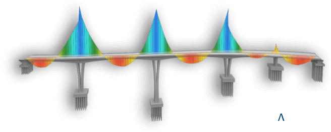
Bridge and civil engineering

A special bridge and civil engineering module is available for the design of bridges, tunnels, supporting structures, ramps, dams and channels. A three-dimensional curve is first generated from the site plan, which can be assigned any cross-sections, taking account of the transverse slope. This produces a complex three-dimensional model, which can be used as the reliable basis for the design and of reinforced concrete.

ALUPLAN PROGRAM SİSTEMLERİ

Son 5 yıldaki tüm geliştirmelere göz atın

Allplan 2015-2020 – Allplan Architecture tüm yenilikler bir arada.

service image
01

Allplan Destek

Read More

Allplan Destek

Allplan Destek: Allplan Serviceplus ağımızın bir üyesi olarak, daima en güncel versiyonu kullanır ve yazılımınızın tüm opsiyonlarından istifade edersiniz. İster yönetici, mimar, ofis müdürü veya yönetici direktör olun: Destek ekiplerimiz sorularınızı hızla ve güvenilir şekilde yanıtlayacaklardır.
service image
02

Allplan Forum

Read More

Allplan Forum

Allplan Forum: Uluslararası servis portalımız Allplan Connect ile, dünya çapındaki Allplan topluluğunun deneyimlerini paylaşabilirsiniz.
service image
03

FEATURES 2016 - 2020

Read More

FEATURES 2016 - 2020

Yeni etkileşimli sürüm karşılaştırmamız size, sadece birkaç tıklamayla, her Allplan sürümüne hangi heyecan verici yeni özelliklerin eklendiğini ve size hangi avantajları sunduğunu söyleyecektir.
ALLPLAN 2020

DENEME
SÜRÜMÜ İNDİR

Allplan ürünlerini, 30 gün boyunca, herhangi bir alım zorunluluğu olmadan kullanın.


Yazılımı indirin ve avantajları gözlerinizle görün.

Allplan Architecture mimarlara tasarım serbestliği ve proje üzerinde tam hakimiyet sağlayan, üst düzey BIM yazılımıdır. Yazılım, detaylı uygulama projelerini benzersiz bilgi içeriği ile oluşturmak için özel olarak tasarlanmıştır.

Başarınızı yükseltin:

  • Fiziksel ve fonksiyonel özellikler tanımlayın
  • Profesyonel çizim ve görseller oluşturun
  • Güvenilir ve takip edilebilir metraj ve maliyetleri hesaplayın.


ALLPLAN SIZE UZMAN DESTEĞI SUNMAKTADIR

Allplan’a geçiş desteği; Allplan yerinde destek: Eğer Allplan’a geçmek isterseniz, bölgenizde bulunan bir iş ortağımız size yazılım uyarlanması ile ilgili uzman destek sağlayacaktır;

İster bir tanıtım, eğitim, geçiş için destek, veri takası, veya yardım ihtiyacınız söz konusu olsun, iş ortağınızla temasa geçiniz.

Herhangi bir sorunuz var mı, veya bağlayıcılığı olmayan bir teklif ister misiniz?

error: Content is protected !!